Things to do in Qamdo
Explore top experiences
Top 10 attractions in Qamdo

Rumei Village
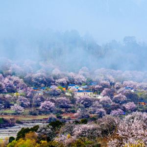
Located at the foot of Lawu Mountain, it is a picturesque and beautiful local village. The Lancang River also flows through it.Markam · 20.8 km from downtown

Duola Sacred Mountain
The scale of Mount Dora is not very large, and it is traditionally divided into an outer ring, a middle ring and an inner ring. It takes about 4 hours to walk around the middle circle on foot. Along the way, you can see the sky burial platform and various stone carving arts. Climbing to the main peak, you can get a bird's-eye view of the entire Dora Mountain. It takes no more than 2 hours to make a circle from the inner circle. This is the core part of Mount Dora, and it is also the main visiting point. On the way, you can worship and appreciate various Buddha statues, pagodas, six-character mantras and Tibetan Prayer. The mystery of Mount Dora lies in the fact that the limestone all over the mountain is full of Buddha statues and six-character mantras. Due to the age, coupled with years of wind and rain, the weathering phenomenon is extremely serious, so it has long lost its artificially carved imprints, which makes many people believe that these Buddha statues and six-character mantras are formed naturally.Basu · 3.3 km from downtown

Laigu Village
Laigu Village is a small village at the end of the famous Laigu Glacier, accompanied by Ranwu Lake. The village is surrounded by snow-capped mountains, surrounded by four peaks, Danggeling, Xana Peak, Bouwangla, and Dayu Barrier. Laigu Village sits scattered among glaciers and snow-capped mountains, cattle and sheep go out of the house, chickens and dogs mingle, pastoral fields, Buddhist pagodas and mulberry smoke, it is a wonderful scene.Basu · 85.9 km from downtown

Yela Mountain
On Yela Mountain, after crossing the mountain pass from Bangda Town at 4,120 m, you reach the famous Zig-Zag Mountain Road With 72 Turns, also known as the "99 Turns." These turns are not only sharp and steep, but most are also U-shaped. Each turn is covered in 20–30 cm of mud, and when cars pass, the mud kicked up by the wheels blots out the sky.[1] One wrong move, and the Nujiang River is waiting for you below. It is a daunting sight and truly a miracle on China's roads!Basu · 39.4 km from downtown

Taniantaweng Mountains
Qamdo · 35 km from downtown

Nujiang Bridge
Basu · 27.7 km from downtown

Jueba Mountain
Jueba Mountain (also known as Jiaoba Mountain) lies in the Three Rivers (Jinsha, Lancang, and Nujiang) basin of the Hengduan Mountains, nestled between the Anjiula Mountains, the Boshula Mountains, and the Lawu Mountains. Jueba Mountain isn't high, with the pass at a mere 3,940 meters above sea level. However, due to the deep undercutting of the Lancang River over millennia, the riverbanks are sheer cliffs, creating a desolate and rugged appearance, giving the impression of lofty mountains and deep valleys. This is one of the most dangerous sections of the Hengduan Mountains. The 30-kilometer winding road and nearly 2,000-meter elevation difference make Jueba Mountain one of the most challenging and time-consuming climbs on the Sichuan-Tibet Highway. The road, which stretches along the cliffs, lacks guardrails or road signs. Many sections are carved directly into the mountainside, leaning against the cliffs above and dangling from the abyss below. Although the Sichuan-Tibet Highway is known for its natural dangers, there are actually only a few, such as the Pailong, Tongmai, and Nujiang natural barriers. Compared with these famous natural dangers, Jueba Mountain is indeed not well-known. Only those who have experienced it in person will know that this unknown natural danger is just as daunting as the other famous ones.Markam · 30.4 km from downtown

Bangda Grassland
Located in the high mountains and deep valleys of the Sanjiang River Basin in the Qamdo region, the Bangda Grassland is an alpine grassland with gentle terrain and lush water plants. The upper reaches of Yuqu, a tributary of the Nujiang River, meanders through it. On the broad low-wet beaches on both sides of the river, there are dense and low meadow plants such as wormwood and serratia. , and occasionally there will be some Tibetan gazelles in the meantime. This is a relatively fine grassland in Tibet. The unique and prosperous grassland environment has also made Bangda the main producing area of many medicinal plants, such as Fritillaria, ginseng fruit, rhubarb, large-leaf chinensis and rhodiola, among which the well-known is Cordyceps sinensis, which is very precious. It used to be the place where the famous "Tea-Horse Road" must pass in the past. Now it has opened up Sichuan-Tibet, Sichuan-Yunnan and other highways connecting Tibet and neighboring provinces such as Sichuan, Yunnan and Qinghai. In 1995, a state was established on this plateau. It reached the airport and opened up the air route from Qamdo to Chengdu.Basu · 56.4 km from downtown

Qamdo Museum
Changdu Museum has two buildings, the south and north wings, with a total exhibition area of more than 8,000 m². The museum's collections are extensive, and the exhibits cover multiple themes, including Sanjiang civilization, tea-horse culture, and painting.Qamdo · 1.1 km from downtown

Lawu Mountain
Markam · 19m from downtown
Experiences you can't miss in Qamdo
Featured Travel photography in Qamdo
View all Travel photography


5.0/5
· 1 reviewInstant confirmation
Book now for today
FromQAR 61.35

Instant confirmation
Book now for today
FromQAR 122.69

FromQAR 1,472.21

FromQAR 736.11

FromQAR 736.11
Featured SIM card in Qamdo
View all SIM card
4.6/5
· 70.8k reviews· 2.1mil bookedFree cancellation
Book now for today
Fast-selling Wi-Fi & SIM cards
50% off
Limited-time sale
FromQAR 0.32QAR 0.64

4.6/5
· 32.2k reviews· 954.1k bookedFree cancellation
Book now for today
Fast-selling Wi-Fi & SIM cards
50% off
Limited-time sale
FromQAR 0.32QAR 0.64

4.6/5
· 23.8k reviews· 666.2k bookedFree cancellation
Book now for today
91.2% of travelers recommend
50% off
Limited-time sale
FromQAR 0.32QAR 0.64
4.5/5
· 10k reviews· 247.9k bookedFree cancellation
Book now for today
Fast-selling Wi-Fi & SIM cards
50% off
Limited-time sale
FromQAR 0.30QAR 0.6

4.6/5
· 9.2k reviews· 243.7k bookedFree cancellation
Book now for today
23 consecutive positive reviews
50% off
Limited-time sale
FromQAR 0.29QAR 0.58

4.5/5
· 6.7k reviews· 198.6k bookedFree cancellation
Book now for today
10.75k bookings in 7 days
50% off
Limited-time sale
FromQAR 0.29QAR 0.58

4.7/5
· 5.5k reviews· 141.6k bookedFree cancellation
Book now for today
92.5% of travelers recommend
50% off
Limited-time sale
FromQAR 0.29QAR 0.58

4.6/5
· 6.9k reviews· 180.5k bookedFree cancellation
Book now for today
91.7% of travelers recommend
50% off
Limited-time sale
FromQAR 0.30QAR 0.6
More things to do
Group Tours in Qamdo
View More Group Tours in Qamdo


Free things to do in Qamdo


What travelers say about Qamdo

enjoyzentJuly 22, 2020
4.0
Rumei Village is located in the west of Mangkang County, at an altitude of about 3,100 meters. It is a small village in the valley under Jueba Mountain.
Rumei Village is a poor village, mainly engaged in agriculture and animal husbandry, half farming and half animal husbandry, raising livestock and poultry such as yaks, horses, sheep, Tibetan fragrant pigs, and planting crops such as corn, barley, radix and walnuts. Therefore, it is not a traditional tourist attraction. It is a resting place chosen by many travelers who enter Tibet by hiking or cycling when crossing the long slope of Jueba Mountain.
Perhaps while bringing convenience to tired people, Rumei Village also left an impression of "beauty", just like an oasis in the desert, rooted in people's memory.
Rumei Village

格格巴December 8, 2019
4.0
On National Highway 318, in Baima Town, Basu County, Changdu, there is also such a sacred mountain, called Dora Sacred Mountain. A mountain where words can grow on stones. In the snowy plateau with high mountains and forests, if measured by altitude, Dora Sacred Mountain is not outstanding, but this mountain has many believers around it and even attracted the attention of many scholars.
Duola Sacred Mountain

Elanie0702March 16, 2025
5.0
冬天去的,天气很冷,要住在一个有暖气或者电热毯的酒店才可以,晚上还有可能因为太冷了,热水器会被冻住而没有办法洗漱,但是还是值得住一晚的,第二天方便去雅隆冰川
Laigu Village

倩ang🍓🍉🍑🍒August 25, 2025
5.0
Yela Mountain is a "cloud-topped viewing platform" gifted by the Hengduan Mountains. At 4,658 meters, the pass, with its majestic Nujiang Gorge on one side and the vast Bangda Grassland on the other, hides the most dynamic scenery along the Sichuan-Tibet Highway.
The wind here is particularly powerful, rustling prayer flags and making the stone carvings on the Mani piles gleam with ancient charm in the sunlight. Looking up, snow-capped peaks pierce the sky; looking down, clouds swirl through the canyon, occasionally a soaring eagle carves a free arc.
Spinning down from the pass, you'll find the famous 72 bends of the Nujiang River. The mountain breeze still echoes the whispers of wheels and curves, while the prayer flags at the pass have long since carried the awe of countless travelers to the distant blue sky.
Yela Mountain

binger1031July 22, 2022
5.0
1. The Nujiang Bridge and Tiger Mouth section are often subject to traffic control, especially during the rainy season. The hotel owner said that as long as it rains, landslides are very likely to occur due to geological reasons, which is very dangerous. It is usually closed at 8 pm and will be opened the next day depending on the situation. When it is sunny, even steel cannot pry the cliff.
2. I originally liked such rocks, the exposed rocks are crumbling, revealing a sense of desolation. But... the traffic control was blocked for several hours. I saw a car being hit by falling rocks on the way and realized that this is the other side of 318, or the more real side. The Nujiang Bridge is almost a bridge built in the gap of the Nujiang Gorge. It is a miracle in the history of Chinese roads and is called the throat of the Sichuan-Tibet Highway. On one side, the river water hits the shore and sighs at the magic of nature, and on the other side, the cliffs cut by knives and axes make people miss the era of "letting the mountains bow their heads and let the rivers give way". The strong wind in the canyon cannot take away the great achievements of the ancestors, the surging river water cannot flow away the great achievements of the ancestors, and the dust of the years cannot forget the tragic stories of the ancestors. This old bridge, which solidified the blood and lives of our ancestors, has been replaced by a new bridge, but that spirit, like Highway 318, will always exist on the vast plateau. Along the way, what impressed me most was not only how shocking the scenery was, but also how difficult it was to build this highway.
Nujiang Bridge

GeographerFebruary 8, 2021
5.0
After crossing the Lancang River on 318, you will start to climb the mountain along the Lancang River valley on the cliff. This mountain is Jueba Mountain. The altitude is not high, and the pass is less than 4,000 meters, but the route is really dangerous. The Jueba Mountain Tunnel has begun construction.
Jueba Mountain

非凡轶生September 6, 2023
5.0
The Bonda Grassland is located in the Qamdo area of the Tibet Autonomous Region. It is a high-altitude grassland with a wide and gentle terrain and abundant water and grass. The Bonda Grassland is more than 130 kilometers away from Basu County.
Bangda Grassland

刘闲人December 18, 2022
5.0
The Qamdo City Museum is located in Karuo District, Qamdo City, east of the Qamdo Temple. The Qamdo City Museum is very large, and there is a dinosaur skeleton in the entrance hall. The museum has two floors. The cultural relics on display not only reflect the unique culture of the Tibetan area, but also witness the history of the Tibetan area in different periods. The traditional Tibetan daily utensils are decorated with unique patterns and gems, which are very exquisite and reflect the scenes of Tibetan life and customs. The museum also displays many ancient thangkas, which are brightly colored and timeless.
Qamdo Museum

小民2011January 10, 2020
5.0
Lawu Mountain is a gentle mountain pass in Mangkang, Tibet, on the Sichuan-Tibet Highway 318. There is a spectacular prayer flag array on the top of the mountain, which is the largest I have ever seen, occupying the entire mountain. Lawu Pass is not very high, only 4,338 meters, but if you stand on the pass, you can overlook the Jinsha River and the Lancang River if you have a sky eye.
Lawu Mountain